


A giant leap for the infrastructure development of the region, Rajpura Master Plan 2031 aims to promote sustainable land use patterns for various purposes. This plan has been launched by Greater Mohali Area Development Authority (GMADA) and Punjab Urban Planning and Development Authority (PUDA) for infrastructural growth in the region. Among the main aims of this plan are extensively planned upgrades for land use patterns for infrastructure projects and affordable housing and transportation for the residents of the region. Explore the key features of the plan, proposed land use pattern and the map of Rajpur Master Plan in this article.
See also: All about Greater Noida Master Plan 2041
Key features
Rajpura Master Plan 2031 aims for the development of a vast range of sectors, ranging from industries, trade and commerce to residential and commercial land use. Here are the main proposals of the plan:
- To enhance the region’s connectivity with roadways between Rajpura and the state capital Chandigarh, a rail link between Rajpura and Mohali has been proposed.
- For smooth functioning of retail and wholesale activities, land for residential, industrial and commercial purposes will be especially designated.
- Plans for construction of new roadways infrastructure, including elevated roads, flyovers, rail over bridges, and pedestrian underpasses and overbridges, are in the pipeline to ensure easy commute.
- Social infrastructure and amenities for education, healthcare and recreation will be developed to serve the needs of the residents.
Proposed land allocation
The land use proposed for the various development projects under Rajpura Master Plan 2031 has been drafted and approved. Following are the details:
| Zone | Definition | Urbanisable limit % |
| Residential | Zone designated for people to live in | 62.06 |
| Commercial | Area specially for shops, businesses and related activities | 0.13 |
| Industrial zone | Areas that will house factories, manufacturing plants and industrial estates | 17.01 |
| Wholesale warehousing zone | Areas for wholesale trading and storage facilities | 3.79 |
| Mix zone | Zones that allow multiple activities and serve a range of purposes | 8.89 |
Source: Greater Mohali Area Development Authority (GMADA)
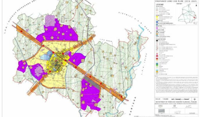
Rajpura Master Plan 2031 map


Source: Greater Mohali Area Development Authority (GMADA)
FAQs
Which government bodies does Rajpura Master Plan 2031 fall under?
The plan is being undertaken by Greater Mohali Area Development Authority (GMADA) and Punjab Urban Development Authority (PUDA).
What are the main aims of the plan?
Among the main aims of this plan are extensively planned upgrades for land use patterns for infrastructure projects and affordable housing and transportation for the residents of the region.
Which regions will be connected by the roadways project under the plan?
The plan aims to enhance connectivity between Rajpura and Chandigarh by enhancing the roadways.
Does the plan have provisions for social infrastructure?
Social infrastructure and amenities for education, healthcare and recreation have been proposed under this plan to serve the needs of the residents.
Which sectors does the plan cover?
This plan covers residential, commercial, industrial and wholesale and warehousing sectors.
Which sector has the highest percentage of designated land under the plan?
The highest percentage of land has been allocated for residential purposes at 62.06 percent.
How much land has been allocated for industrial activities?
17.01 percent of the total land has been allocated for industrial activities.
| Got any questions or point of view on our article? We would love to hear from you. Write to our Editor-in-Chief Jhumur Ghosh at jhumur.ghosh1@housing.com |