Plane table surveying is a graphical way of surveying that is used to generate maps and plans, as well as to gather information such as topographic features via field observations. The plane table surveying method is often used for surveys that do not need a particularly high level of accuracy. The majority of its applications revolve around mapping on a medium or small scale.
see also: Chain surveying technique and mistakes to avoid
Plane table surveying: What is it?
Source: Pinterest
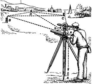
The plane table surveying technique is the most accurate form of surveying. When doing this kind of surveying, both charting the plan and making observations in the field can be done at the same time. In the event of surveying using a plane table, geometrical conditions of the site are hand-written onto the map sheet using an alidade and a plane table. Following this step, topographic features are organised on the map.
Plane Table Surveying: Its goals and objectives
The following is a list of the primary goals that can be accomplished using plane table surveying:
- To do rapid surveying on a very modest scale.
- To run the survey lines between stations that have been previously set by other ways of surveying, this approach is used.
- To find the topographic specifics.
- To conduct surveys in industrial regions, which are not amenable to compass surveying.
- To create maps at a smaller size.
Plane table surveying: The basic idea behind it
The idea of parallelism serves as the foundation for the plane table surveying technique. Following this guiding concept, it is expected that all rays that are pulled via the different details will go through the survey station. In this sense, the location of the plane table is maintained to be consistent throughout all of the different stations. In each station, the plane table must be oriented in the direction that points magnetic north to do this.
Plane table surveying: Types of equipment used
Source: Pinterest
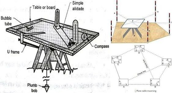
The following types of general equipment are used for carrying out plane table surveys:
- Plane table
- Alidade for sighting (telescopic or simple)
- Plumb bob and plumb fork
- Compass
- Spirit level
- Chain
- Ranging rods
- Tripod
- Drawing sheet and drawing tools
- Paper clips or screws
Plane table surveying: The configuration of the equipment for the plane table survey
There are 3 steps involved in the process of putting up the table:
Levelling
It is recommended that the plane table be put up at a practical height (almost a metre), which can be accomplished by spreading the legs of the table so that it is about levelled above the specific station. After that, the levelling is finished by either tilting the board by hand (if the instrument has a ball and socket arrangement) or by utilising levelling screws, if such are available.
On the table, a level tube or circle level is positioned so that it is parallel to two screws, and then it is positioned so that it is above the third screw. Adjusting the height of the legs is all that is required to achieve levelling if neither the levelling mechanism nor the ball-and-socket system is available.
Orientation
The process of maintaining the position of the table at each of the consecutive stations in a manner that is parallel to the position held by the table at the first station is what is referred to as orientation. If the table is oriented correctly, this means that all of the lines on the paper will be parallel to the lines that correspond to them on the ground. If there is more than one instrument station, this operation will become essential.
If orientation is not done, the board will not be parallel to itself at the various instrument stations, the plan will be obtained by using a different meridian at each station, and the relative plotted positions of various points in the area will be quite different from the ones that are actually there. If orientation is done, the board will be parallel to itself. There are two different ways that the table might be oriented, namely:
- By back sighting
- By magnetic needle.
Centring
In a survey using a basic table, centring the table is a vital step. Setting the table such that it is perpendicular to the ground point is what is meant by “centring.” To carry out this procedure, align the pointed end of the upper leg of the fork with the point on the paper, hang a plumb bob from the lower leg of the fork, and adjust the position of the table body such that the plumb bob of the fork hangs exactly over the centre of the station peg.
Plane table surveying: Methods
Radiation, intersection or triangulation, traversing, and resection are the four primary approaches to plane table surveying.
Radiation method
This technique of plain table survey involves setting up the plane table at only one station. After that, various points are positioned by radiating (drawing) a ray from the instrument station to each of the points and then plotting to scale along the ray the distance measured from the instrument station to the point that is sighted.
The radiation approach is well suited for use in the surveying of smaller regions that can often be directed from a single station. It is most effective when used in conjunction with other strategies when applied to large-scale projects. The task can be completed very quickly, and thus, in this instance, the technique will have a larger reach. If the distances are acquired tacheometrically with the assistance of telescopic alidade (supplied with stadia hairs), the work can be accomplished.
Intersection or triangulation method
This approach is used extensively in the process of charting the specifics on the maps. In addition to this, it can be used for charting the location of points that will be utilised at later stations. The various spots can be found by finding the intersection of rays taken from two distinct stations (A and B), which together create a baseline. The only linear measurement that is necessary is the baseline AB measurement that is taken on the ground.
This approach can also be used to locate items that are far away and difficult to reach, such as rivers; it can also be used to survey mountainous landscapes, which makes it difficult to estimate distances accurately; and it can be used to examine objects that are inaccessible from a distance.
Traversing method
The method of navigating using a plane table is similar to that of using a compass or theodolite. As a result, the procedure can be used to put down the survey lines of either a closed or an unclosed traverse. Plotting the information using the standard method requires taking offsets into consideration. The planar table traversal can also help survey things like highways, rivers, and other features.
Resection
A technique of plane table surveying known as resection assumes that the position of the plane table is unknown. Instead, the location of the plane table is discovered by sighting it at locations that are either known or charted. It is also known as the technique of orientation, and it is possible to carry it out in two different field settings, which are outlined below.
- The two-point problem
- The three-point problem
Two point problem
In this problem, two separate points are chosen, each of which has a location that is already known, and then they are mapped on the paper. The two points are brought together and divided cleanly in half. The new station will serve as the dividing line’s midpoint.
The three-point problem
Under these circumstances, the locations of three points within the field are already established. The plane table has been positioned in such a way that it offers a view of all three locations from its vantage point. Consequently, if we sight all three spots, we will be able to find the spot where the equipment is kept.
Plane table surveying: The many benefits of utilising it

Source: Pinterest
The following is a list of the primary benefits that can be obtained by plane table surveying:
- Plane table surveying is a quick and efficient surveying technique.
- There is no need for work to be done in an office since both making observations and charting are done out in the field.
- Eliminates the omission of measurements and observations.
- It is a highly effective technique for rapidly plotting maps at a tiny size in a short amount of time.
- In magnetic regions where compass surveying is not possible, this method is very helpful.
- It is not very difficult, and it does not call for highly specialised labour or technologically complex equipment.
- This kind of surveying is quite inexpensive.
- The checking of the plotted lines and the field lines is a simple and trouble-free process that can be done effortlessly.
- The field book’s mistakes are eliminated.
- It is not necessary to have a high level of competence to make maps.
- It gives an exact portrayal of the contour as well as the irregularity of the items.
Plane table surveying: The drawback of using plane tables for surveying
The following is a summary of some of the restrictions that are associated with plane table surveying:
- The circumstances of the atmosphere have a significant impact on the plane table survey. It is not possible to carry it out when it’s raining or when there is a strong wind.
- The plane table and all of its components are rather heavy. As a result, working with the equipment that’s being utilised might be challenging and laborious at times.
- It is a time-consuming process since the table has to be put up at each station.
- It does not provide a great degree of precision.
- If the work has to be re-plotted at a different scale or the quantities need to be calculated, it will be impossible to do so since there will be no field book available.
- Due to the reduced visibility, it is not appropriate for use in hazy environments.
- Due to the need to make frequent adjustments to the size of the drawing sheets, it is not suited for use in the surveying of broad areas.
See also: City surveying – Everything you need to know about it
Plane table surveying: Precautions to take during plane table surveying
The following is a list of some of the safety measures that must be taken before beginning the plane table surveying process:
- At each station, the plane table has to be oriented correctly; otherwise, the lines drawn from the new station will not be in agreement with the lines drawn from the previous stations.
- Only a straight ruler can be used to draw the rays in such a way that attention is taken.
- To secure the drawing page, you will need to use paper clips. Because of this, the potential of the drawing sheet being smaller or larger is no longer present.
- It is necessary to plot-check lines to ensure correctness.
- Extreme caution must be used while attempting to centre the alidade.
FAQs
What is known as levelling?
The objective of levelling is to establish, verify, or measure the height of specified locations relative to a datum as a part of surveying. It is often used in cartography to measure geodetic height and in construction to quantify variances in the height of building objects.
How many plane table surveying techniques are there?
Radiation, intersection, traversing, and resection are the four methods that exist for doing plane table surveying. Two are used for identifying specifics, while the remaining two are utilised for locating plane table stations.
What kind of compass is used for plane table surveying?
The simple form of Alidade is used for plane table surveying. Alidade compass has two edges. One is straight, while the other is bevelled. This brass or gunmetal straight edge functions as a ruler. The edge with a bevel is known as the fiducial edge.
What are the fundamentals of surveying?
Always working from the whole to the part and finding a new station using at least two measurements (Linear or angular) from stable reference points are two fundamental surveying concepts.
How is a plane table put up?
The plane table is positioned on a new station, and the alidade is positioned along the line connecting the new station to the previous station. Rotating the table till the line of sight bisects the preceding station.
What is the plane table's limitation?
The plane table is mostly composed of tropical instruments. It is unfit for use in damp climates. This technique of surveying lacks precision and is thus inappropriate for large-scale or exact tasks. Since no field book is kept, charting at various scales requires physical exertion.
Housing News Desk is the news desk of leading online real estate portal, Housing.com. Housing News Desk focuses on a variety of topics such as real estate laws, taxes, current news, property trends, home loans, rentals, décor, green homes, home improvement, etc. The main objective of the news desk, is to cover the real estate sector from the perspective of providing information that is useful to the end-user.
Facebook: https://www.facebook.com/housing.com/
Twitter: https://twitter.com/Housing
Email: [email protected]


