The 1,257-km long and 4/6-lane wide Amritsar-Jamnagar Expressway (NH-754) is currently under development in northwest India. When completed, the motorway between Amritsar and Jamnagar would shorten the distance to 1,316 kilometres (including the Kapurthala–Amritsar segment) and cut travel time from 26 hours to about 13 hours. The Bharatmala and the Amritsar-Jamnagar Economic Corridor pass through this area (EC-3).
It travels through four different states: Punjab, Haryana, Rajasthan, and Gujarat. Since it would link the massive oil refineries at HMEL Bathinda, HPCL Barmer, and RIL Jamnagar, the highway is crucial to national security. Furthermore, it will link the Guru Nanak Dev Thermal Plant (Bathinda) to the Suratgarh Super Thermal Power Plant (Sri Ganganagar). The expressway would connect to the Pathankot-Ajmer Economic Corridor’s Ludhiana-Bathinda-Ajmer Expressway at Bathinda. The highway across Haryana and Rajasthan would be finished in October 2023 after construction began in 2019.
Amritsar–Jamnagar Expressway: Key facts
| Total Estimated Cost: | Rs. 80,000 crore |
| Project’s Total Length: | 1256.951 km |
| Lanes: | 4-6 |
| Current Status: | Under Construction, Bidding Underway & Land Acquisition Underway |
| Deadline: | October 2023 |
| Owner: | National Highways Authority of India (NHAI) |
| Project Model: | Engineering, procurement, and construction (EPC) and Hybrid Annuity Model (HAM) |
Amritsar–Jamnagar Expressway: Connectivity
The National Highways Authority of India (NHAI) is presently constructing this project as part of Bharatmala Pariyojana Phase-I; the Amritsar-Jamnagar Economic Corridor is one of 44 projected economic corridors and has been designated as Economic Corridor (EC)-3 and National Highway (NH)-3 (NH-754).
The cities of Amritsar, Bhatinda, Sanaria, Bikaner, Sanchore, Samakhiyali, and Jamnagar are all important economic nodes that the route will traverse. More than half of the highway will go through the Indian state of Rajasthan. The corridor would link the major cities of north India, including those with important industrial and agricultural sectors, to the Kandla and Jamnagar ports in the country’s west.
When finished, the highway would provide cities like Bhatinda, Ludhiana, and Baddi with a significant economic boost. The Delhi-Amritsar-Katra Expressway would link the national capital with Jammu, Kashmir, and the Amritsar-Jamnagar Expressway. The motorway would link up from Bathinda with the Pathankot-Ajmer Economic Corridor and the Ludhiana-Bathinda-Ajmer Expressway.
Amritsar-Jamnagar Expressway: Route
Here is all you need to know about the route of Amritsar-Jamnagar Expressway and all the cities it traverses in each state.
Amritsar-Jamnagar Expressway: Route in Punjab
- Amritsar to Tibba on NE-5A
- NH-703 Moga to Jalandhar Road with an intersection near Dharamkot
- Bhagta Bhai ka to Bhadaur Road, with an intersection near Dyalpura Bhai Ka
- Rampura Phul intersecting with Ludhiana-Bathinda Expressway section of Pathankot–Ajmer Expressway
- NH-54 Mandi Dabwali to Bathinda Road, with an intersection near Sangat Kalan
Amritsar-Jamnagar Expressway: Route in Haryana
- Starts at Mandi Dabwali
- Ends at Haryana/Rajasthan border at Chautala village
- Runs entirely through the Sirsa district
Amritsar-Jamnagar Expressway: Route in Rajasthan
- Starts from Sangaria town in the Hanumangarh district
- Passes through districts of Bikaner, Jodhpur and Barmer
- Ends at Rajasthan, Sanchore town in Jalore district
Amritsar-Jamnagar Expressway: Route in Gujarat
- Starts at Vantdau in the Banaskantha district
- Traverses Patan, Kutch and Morbi districts
- Ends in Jamnagar
Amritsar–Jamnagar Expressway: Map
Here is a complete map of the Amritsar-Jamnagar Expressway project that starts from Tibba Village on the Delhi Amritsar Expressway and terminates in Jamnagar. Discover the location of all the towns and cities the expressway traverses.
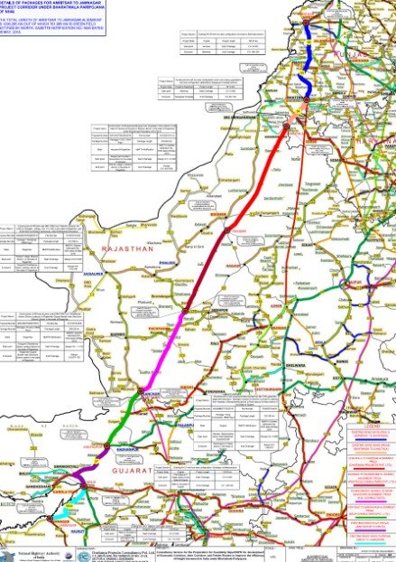
Source: The Metro Rail Guy
Amritsar–Jamnagar Expressway: Features
Other stretches of the motorway are built as four lanes partly access controlled and some as six-lane completely access-controlled roadways in response to analyses and studies of traffic patterns. The total length of the Amritsar-Jamnagar Economic Corridor is estimated to be 1,257 kilometres; of this, 917 kilometres will be motorway built as six lanes access controlled motorway where an entirely new alignment is adopted, while the remaining 340 kilometres will be built as a brownfield type motorway where the existing highways are upgraded to motorway standard.
Construction of 5 Railway Over Bridge, 20 Major Bridge, 64 Minor Bridge, 55 Vehicular Underpass, 126 Light Vehicular Underpass, 311 Small Vehicular Underpass, 26 Interchanges, and 1057 culverts is underway along the Amritsar Jamnagar Economic Corridor.
The Amritsar Jamnagar Economic Corridor will have the right of way of 70m and a motorway design that allows for speeds of up to 100 km/h. This highway will have a state-of-the-art traffic control system with CCTV cameras, emergency phone booths, electricity in-car charging stations, and more. This motorway will have lanes 3.50 metres wide, and the highway’s roadway will be made of Bitumen or asphalt because of its flexibility.
Amritsar–Jamnagar Expressway: Significance
Imports and exports will increase due to the improved speed and reliability of transportation linking Central and Northern India to Gujarat’s Kandla Port. This Economic Corridor will run parallel to and through India’s three largest refineries. It will pass through the Bathinda Oil Refinery in Punjab, the HPCL oil refinery in Pachpadra, Rajasthan, which is part of the Barmer District, where India’s second-largest oil reserve is also being built, and the Jamnagar Oil Refinery in Gujarat, owned by Reliance Industries Limited and the largest oil refinery in the world. The expressway’s proximity to several refineries and thermal power plants significantly boosts the region’s industrialisation, corporate expansion, and socioeconomic development.
Amritsar–Jamnagar Expressway: Sections
There are eight parts to the Amritsar-Jamnagar Economic Corridor, five of which are greenfield and three of which are brownfield. The total number of building packages for this project is 30 if those in each component are added together.
- One section connects Tibba Village in Punjab’s Kapurthala District to Sangatkalan in Bathinda. In addition to being known as the Amritsar Bathinda Expressway, this segment has a total length of 155 kilometres. A six-lane, access-controlled greenfield highway is being built in Section 1. National Highway NH-754 A, Section 1 of the highway, has been divided into three construction packages.
- The highway from Bathinda, Punjab, to Chautala, Haryana, is another section of the Amritsar Jamnagar motorway. It’s an approximately 85-kilometre stretch being expanded from a two to four-lane motorway as part of a brownfield redevelopment project.
- A stretch of the Amritsar Jamnagar motorway links the cities of Chautala in Haryana with Rasisar in Rajasthan. This segment is around 253 kilometres in length. This segment, NH-754K, is being built as a six-lane, greenfield, access-controlled motorway. This part of the building project is broken down into nine separate packages.
- With a total length of around 176 kilometres, a section of the Economic Corridor in Rajasthan would stretch from Rasisar in the Bikaner district to Deogarh in the Jodhpur district. A six-lane greenfield motorway with complete access control will be built here. You may also see the designation “NH 754-K” attached to this part of the highway. Regarding building things, this subsection four is broken down into six different bundles.
- This stretch of the Amritsar Jamnagar Expressway connects two cities in Rajasthan: Deogarh in the District of Jodhpur and Sanchore in the District of Jalore. Greenfield 6 lane completely access-controlled highway, about 208 km in length. Additionally, this stretch is marked as National Highway 754-K. It’s been broken down even further into eight distinct bundles covering certain production phases.
- Sanchore, in Rajasthan, and Santalpur, District Patan, Gujarat, would be linked by this section of the economic corridor. This stretch is 124 kilometres long, similar to a 6-lane access-controlled greenfield highway. Note that NH-754k is another designation for this particular segment. It’s broken up into four packages, each designed for a certain kind of building.
- The distance travelled by this section is about 124 kilometres from Santalpur in the Patan district to Malia in the Morbi district in Gujarat. The existing 2-lane highway is being expanded to the 4-lane motorway in this brownfield segment of the project. In this part, there will be no toll booths or other barriers to entry.
- With this section of the Amritsar Jamnagar Economic Corridor, you may travel from Malia to the city of Jamnagar in the Indian state of Gujarat. Section 8 is a brownfield segment of the project that spans 131 km and involves expanding and improving pre-existing national roads to motorway standards. Access to this area will be mostly restricted.
Amritsar Jamnagar Expressway: Impact on real estate
The Amritsar-Jamnagar expressway, an ambitious project by the Government of India, is set to revolutionise the nation’s connectivity. This infrastructure development is expected to create employment opportunities, improve livability, and drive growth in the real estate sector across the cities it traverses.
The expressway will significantly reduce travel time between Amritsar and Jamnagar, promoting the establishment of new projects along its route. This will enhance the quality of life for residents, while also generating employment and economic prospects through the development of townships, industrial zones and business parks.
FAQs
What is the Amritsar to Jamnagar motorway project?
The NHAI is building this 1,224 km access-controlled Greenfield Highway project. It will connect the state borders of Gujarat and Rajasthan to the section of NH-754A in Santalpur. The project should be done by September 2023. It will cost a total of Rs 80,000 crores, which includes the cost of buying land.
How many states are connected by the Amritsar-Jamnagar greenfield corridor?
The corridor will link the economic towns of Bhatinda, Amritsar, Sangaria, Bikaner, Sanchore, Jamnagar, and Samakhiyali in the four states of Punjab, Gujarat, Haryana, and Rajasthan.
| Got any questions or point of view on our article? We would love to hear from you. Write to our Editor-in-Chief Jhumur Ghosh at jhumur.ghosh1@housing.com |

Dhwani is a content management expert with over five years of professional experience. She has authored articles spanning diverse domains, including real estate, finance, business, health, taxation, education and more. Holding a Bachelor’s degree in Journalism and Mass Communication, Dhwani’s interests encompass reading and travelling. She is dedicated to staying updated on the latest real estate advancements in India.
Email: dhwani.meharchandani@housing.com