
Managing land records has become more straightforward thanks to new technology and initiatives led by DLRS UP (Department of Land Records and Survey, Uttar Pradesh). One of the most effective tools in this effort is Bhunaksha, a software developed by India’s National Informatics Center. It plays a key role in digitizing land records and making it easier to track property ownership. For residents of Uttar Pradesh, the Bhunaksha website—managed under the oversight of DLRS Uttar Pradesh—allows you to check and download your land maps online. With the latest update, Bhu Naksha 2025 , you can view your land details anytime. This guide will show you how to use Bhunaksha to effectively check and manage your land records.
What’s new in Bhu Naksha 2025?
The 2025 version of Bhu Naksha UP comes with several key upgrades compared to previous iterations. Users will notice a faster, more responsive interface with improved map loading times, especially on mobile browsers. The number of districts covered has expanded, with updated cadastral data for newly digitised tehsils. Map resolution has also improved, offering clearer boundary lines and more accurate plot overlays. Additionally, synchronization with Bhulekh UP records has been refined, making ownership and land-use data more consistent across both platforms. These improvements aim to enhance usability and reduce discrepancies during land verification.
Data source, accuracy, and update frequency
The cadastral data displayed on the Bhu Naksha UP portal is derived from digitised village maps maintained by respective Tehsil Survey Departments across Uttar Pradesh. These base maps are created from 1:4000 or 1:8000 scale village sheets, originally prepared during revenue surveys. They serve as the foundational reference for digitisation and are continuously updated through data inputs received from mutation and Jamabandi (record-of-rights) cycles, which are typically refreshed every six months for ownership changes and every few years for re-surveys.
The accuracy of these digital maps depends on the survey year and the extent of ground verification completed in each district. Areas recently surveyed under state modernisation initiatives tend to have higher positional accuracy and cleaner boundary alignment.
To further improve precision, the Department of Land Records and Survey (DLRS) is integrating GPS and GIS validation under the SVAMITVA scheme, using drone-based mapping for rural parcels. These efforts aim to reduce coordinate deviation errors and bring UP’s cadastral data in line with national geospatial standards, ensuring consistency between spatial (Bhu Naksha) and textual (Bhulekh) land records.
What is Bhunaksha UP and how does it work?
Bhunaksha UP (or UP Bhoomi Naksha) is a digital cadastral mapping system developed by the National Informatics Centre (NIC) under the Government of India to modernize land record management in Uttar Pradesh. It provides a visual representation of land parcels (plots) along with ownership details as recorded in the UP Bhulekh database, ensuring accuracy, transparency, and accessibility in land administration.
Through Bhunaksha UP, property owners, buyers, and government officials can easily access digitized maps (khasra maps) that show boundaries, survey numbers, and adjoining plots. Each plot is assigned a unique Khasra number, which can be cross-verified with corresponding Khatauni (ownership records) to confirm legal ownership and land classification (agricultural, residential, or commercial).
The system integrates spatial (map-based) and textual (ownership) data, allowing users to:
- View and verify land boundaries with satellite-verified accuracy.
- Check plot details such as area, khasra number, and land type.
- Download and print the land map (Bhu Naksha) for official or personal use.
- Prevent land disputes through easy verification of boundaries and ownership records.
To access the Bhu Naksha, users can visit www.upbhunaksha.gov.in, select the district, tehsil, village, and plot number, and then view or download the latest Bhu Naksha 2024. The portal provides a user-friendly interface that bridges the gap between citizens and the government, making land information easily accessible for verification, transactions, and legal documentation.
Legal framework governing Bhu Naksha UP
Bhu Naksha UP functions under the broader framework of the Digital India Land Records Modernization Programme (DILRMP), launched by the Government of India to unify spatial and textual land data across all states. This initiative—an evolution of the earlier National Land Records Modernization Programme (NLRMP)—was designed to digitize land records, ensure conclusive land titling, and minimize disputes arising from overlapping ownership claims.
In Uttar Pradesh, the implementation and oversight of Bhu Naksha fall under the Department of Revenue and the Department of Land Records and Survey (DLRS). The platform operates in accordance with the provisions of the Uttar Pradesh Revenue Code, 2006, which empowers revenue authorities to maintain and authenticate land ownership, mutation, and cadastral mapping records. Together, these frameworks ensure that Bhu Naksha’s operations have a statutory basis, giving its data administrative validity even if not full legal admissibility in court without certification.
What information does UP bhunaksha provide?
A land map is a detailed document that provides detailed information of any plot. It is a digital map that shows the boundaries, area, use, ownership, and other important details of the land. Let us understand the main features of the UP bhu naksha in detail:
Boundaries
Clear boundaries: The land map shows the exact boundaries of any plot of land. This may include boundaries with neighboring plots, roads, rivers or other natural boundaries.
Coordinates: Most modern land maps contain geographic coordinates (such as latitude and longitude) that determine the exact location of the plot.
Area
Total area: The land map shows the total area of any plot of land in square meters or hectares.
Area calculation: This area is calculated by measuring the boundaries of the plot and using appropriate formulas.
Land Use
Current use: The land map shows the use of the land at present. For example, it may show agricultural, residential, commercial, industrial, or other uses.
Future use: Some maps may also contain information about the use of the land in the future, such as according to development plans or zoning regulations.
Ownership
Owner’s name: The land map clearly shows the name of the owner or owners of the land.
Ownership type: It shows whether the ownership is full, partial or of other types.
Document number: The land map may also contain the numbers of the relevant documents, such as Khasra number, Khatauni number, etc.
Other important details
Structures: The land map shows all the structures present on the plot, such as houses, warehouses, walls, etc.
Rivers and streams: Rivers, streams and other water bodies are also shown in the land map.
Roads: Roads, paths and other traffic routes are also included in the land map.
Elevation: Some land maps also show the elevation of the plot.
Soil type: Some maps may contain information about the type of soil of the plot.
Bhu naksha uttar pradesh: How to view and download UP land map online
Step 1: Visit the official website of Bhu Naksha Uttar Pradesh at https://upbhunaksha.gov.in/
Step 2: Enter required details such as district, tehsil and village.
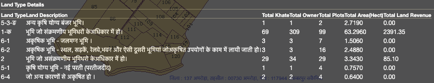
Step 3: To understand the land type, simply click on ‘Show Land Type Details’. This will help you understand whether the land is barren, uncultivable, farmland/agricultural land, government land, etc.
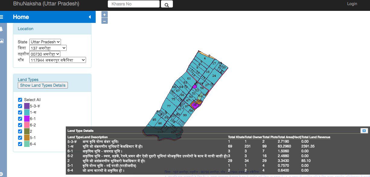
Land type details on Bhu naksha UP
To check the land type, click on ‘Land type’ and ‘Show land type details’ on the right-hand side.
Step 4: You can also click and zoom in on the land area you wish to know about for more details.

How to download your village or plot map in PDF?
Downloading your village or individual plot map from the UP Bhu Naksha portal is easy and can be done without any login. Follow these steps:
- Go to the official portal
Visit https://upbhunaksha.gov.in - Select your location
Choose the correct District, Tehsil, and Village from the drop-down menus. - Locate your plot
The map of your village will appear. Click on the specific plot (Khasra number) to highlight it. The plot details will appear on the right-hand side. - Click on “Map Report”
On the right panel, you will find a button titled “Map Report”. Click it to generate a plot-wise PDF report. - Download the PDF
The system will create a printable PDF version of the selected map, showing boundaries, khasra details, and ownership info. You can then click “Download” or use the browser’s print/save function.
💡 Tip: If you’re looking for the entire village map, click on “Generate Village Map Report” (if available in your district) instead of an individual plot.
Note: The “Village Map Report” provides a full layout of all plots in the village, useful for general reference. The “Map Report” (Khasra-wise) is specific to an individual plot and is better suited for property transactions or resolving disputes.
See also: How to check Bhu Naksha in different states?
How to check UP land codes using UP bhulekh naksha and bhu naksha?
Depending on its use and possession, various codes are used to denote different land on the UP Bhu Naksha portal. Find UP Land Codes and Plot Ownership on Bhulekh UP using the list below.


How to match Bhu Naksha data with Bhulekh UP records?
Bhu Naksha and Bhulekh UP serve different but complementary purposes. While Bhu Naksha provides visual land maps, Bhulekh UP offers textual ownership records like Khasra and Khatauni. You should always cross-reference both portals to get a complete and verified view of your land details.
Steps to match land records
- Note your Khasra number from the Bhulekh UP portal (upbhulekh.gov.in).
- Visit Bhu Naksha UP (upbhunaksha.gov.in) and enter the same district, tehsil, and village.
- Use the Khasra number to identify your plot visually on the map.
- Cross-check details such as:
- Owner’s name
- Land area
- Land type
- Boundaries
- If the map shows mismatched ownership or usage, consult the local Tehsil office or Lekhpal for resolution.
Quick comparison table:
| Data Point | Bhulekh UP (Textual) | Bhu Naksha UP (Map) |
| Owner’s Name | ✅ | ✅ |
| Khasra Number | ✅ | ✅ |
| Area (in sq. m/ha) | ✅ | ✅ |
| Boundary Shape | ❌ | ✅ |
| Soil Type/Land Use | ❌ | ✅ |
| Legal Status | ✅ | ❌ |
How to check mutation status using Bhu Naksha UP and Bhulekh?
One of the most crucial steps while verifying land ownership is ensuring that the mutation status is updated after a sale, inheritance, or transfer. Mutation reflects the legal transfer of title in government revenue records, and a mismatch between textual records (Bhulekh) and spatial data (Bhu Naksha) can raise red flags during transactions.
To check the bhu naksha mutation status, follow these steps:
- Visit the Bhulekh UP portal
Go to upbhulekh.gov.in and select the “View copy of Khatauni (Record of Rights – RoR)” option. Enter the district, tehsil, village, and Khasra number or owner’s name. - Verify updated owner details
The portal will display the name(s) of the current khata holder. Ensure it reflects the new owner’s name post-sale, inheritance, or court order. If the khatauni still shows the previous owner, the mutation hasn’t been updated. - Cross-reference with Bhu Naksha UP
Now, visit upbhunaksha.gov.in and locate the same Khasra number using district, tehsil, and village filters. - Match ownership and plot boundaries
Check if the map details (owner name, area, usage) match the textual details from Bhulekh. While Bhu Naksha may not directly show mutation status, it reflects the plot’s ownership and boundaries from the revenue records. - Discrepancy alert
If the Bhu Naksha still shows the older owner or outdated usage (e.g., showing agricultural land after residential conversion), contact the local Tehsil office or Lekhpal to update mutation records in both systems.
🔍 Pro tip: Mutation updates in Bhulekh are often faster than spatial updates in Bhu Naksha. Always compare both to ensure consistency before any land transaction.
List of districts available on UP Bhu Naksha
The UP Bhu Naksha portal provides digital access to land maps and cadastral records for multiple districts across the state. The government continues to expand its coverage, and more districts will be added soon. Currently, the following districts are available:
- Agra
- Aligarh
- Ambedkar Nagar
- Amethi
- Amroha
- Auraiya
- Ayodhya
- Azamgarh
- Baghpat
- Bahraich
- Ballia
- Balrampur
- Banda
- Barabanki
- Bareilly
- Basti
- Bijnor
- Budaun
- Bulandshahar
- Chandauli
- Chitrakoot
- Deoria
- Etah
- Etawah
- Farrukhabad
- Fatehpur
- Firozabad
- Gautam Buddha Nagar
- Ghaziabad
- Ghazipur
- Gonda
- Gorakhpur
- Hamirpur
- Hapur
- Hardoi
- Hathras
- Jalaun
- Jaunpur
- Jhansi
- Kannauj
- Kanpur Dehat
- Kanpur Nagar
- Kasganj
- Kaushambi
- Kheri
- Kushinagar
- Lalitpur
- Lucknow
- Mahoba
- Maharajganj
- Mainpuri
- Mathura
- Mau
- Meerut
- Mirzapur
- Moradabad
- Muzaffarnagar
- Pilibhit
- Pratapgarh
- Prayagraj
- Rae Bareli
- Rampur
- Saharanpur
- Sambhal
- Sant Kabir Nagar
- Sant Ravidas Nagar (Bhadohi)
- Shahjahanpur
- Shamli
- Shrawasti
- Siddharthnagar
- Sitapur
- Sonbhadra
- Sultanpur
- Unnao
- Varanasi
Understanding Land Codes
In Bhu Naksha, land codes are used to classify and identify different types of land based on their usage, ownership, and legal status. Each code represents a specific category of land, and understanding these codes is essential for anyone trying to interpret land records accurately. Here is a breakdown of some common land codes and their meanings:
- Banjar (Barren Land):
- This code refers to land that is not currently suitable for cultivation or development. It could be barren or uncultivable land, often left unused.
- Talab (Pond):
- A plot marked as Talab refers to a water body or a pond, which is typically used for storing water. This land is generally not meant for construction or cultivation.
- Kuan (Well):
- Land marked with the Kuan code indicates the presence of a well. These areas are typically used for water storage or harvesting, rather than for residential or commercial use.
- Khaad ke Gaddhe (Pit for Manure):
- This code is used for plots that are used to store manure or compost. Such areas are generally agricultural in nature but not meant for building.
- Khalihan (Agricultural Land):
- Khalihan refers to land that is used for farming or agricultural purposes. It indicates that the land is actively used for growing crops or other agricultural activities.
- Aabadi (Residential Area):
- This code represents residential land or areas that are designated for residential use. It is meant for constructing homes or living spaces.
- Rekha Rasta (Road):
- Land designated with this code represents roads or paths that are used for public access. This type of land is not available for personal ownership or development.
- Chakrod (Land for Common Use):
- Chakrod refers to land that is commonly used by a community, often for activities such as grazing or other collective uses.
- STV (Specific Use Land):
- These codes denote land designated for specific uses, such as industrial or commercial purposes, with detailed zoning restrictions.
- Bag (Bagh / Orchard Land):
Land used for growing trees, fruit-bearing plants, or orchards. It’s classified as agricultural but may have limited construction rights. - Jungle / Jungle Jhari:
Refers to forest or shrub land. This land is protected under forest laws and cannot be converted without government approval. - Parti / Parti Kadim:
Uncultivated land that can potentially be brought under cultivation. It’s different from Banjar, as it’s temporarily unused rather than permanently barren. - Pokhar / Jheel (Lake):
Larger natural or man-made water bodies — these are ecologically sensitive zones and are non-buildable. - Gairmazarua Aam (Public Non-Transferable Land):
Common land owned by the government but used by the public for communal purposes like grazing or fairs. - Gairmazarua Khas (Government-Owned Land):
Land owned by the government, which can be allotted or leased for specific uses under administrative orders. - Talai (Small Water Tank):
Smaller version of a pond, often used in rural irrigation systems. - Kabristan / Shamshan (Burial or Cremation Ground):
Land reserved for religious or community burial or cremation purposes — strictly non-transferable. - Abadi Bahar (Land Outside Abadi):
Refers to land located just outside residential limits — may be agricultural or semi-urban, often subject to development approval. - Rasta (Village Path):
Denotes village-level access routes connecting farms or houses, distinct from main public roads.
Each land code serves as a quick reference for identifying the specific purpose or use of a plot of land. By understanding these codes, users can better interpret the data displayed on Bhu Naksha and make informed decisions regarding land purchase, development, or other legal matters.
Difference between Sajra map, Bhunaksha, and Bhulekh maps
When dealing with land-related information in Uttar Pradesh, it’s common to encounter terms like Sajra map, Bhunaksha, and Bhulekh map. Though they all relate to land records, each serves a different purpose and is issued or maintained by different authorities.
| Map Type | Purpose | Issued By | Contains | Legal Validity |
| Sajra Map | Traditional village map used for land demarcation and ownership records | Lekhpal / Revenue Department | Khasra numbers, owner names, plot boundaries, neighboring plots | Used in legal and revenue matters |
| Bhunaksha | Digitized cadastral map for online viewing of land parcels | National Informatics Centre (NIC), under DLRS UP | Geographical layout, plot shape, area, land use, coordinates, boundary overlays | For reference only; not legally binding |
| Bhulekh Map | Text-based record showing land ownership and tenancy details | DLRS Uttar Pradesh / Bhulekh UP portal | Khatauni, Khasra number, owner’s name, crop details, mutation status | Legally accepted for ownership and revenue proof |
How to access and interpret land maps on the UP bhu naksha portal?
The Bhu-Naksha portal is a valuable tool for accessing detailed land maps in Uttar Pradesh. To effectively utilize this resource, follow these steps:
- Visit the Official Bhu-Naksha UP Website:
- Navigate to https://upbhunaksha.gov.in/.
- Enter Required Details:
- Select your District, Tehsil, and Village from the dropdown menus.
- View Land Map:
- Click on “Show Land Details” to display the land map of the selected area.
- Interpret Land Details:
- The map will display various land types, such as agricultural land, barren land, government land, etc.
- Click on specific plots to view detailed information, including plot size, owner details, and land type.
- Download or Print the Map:
- To download or print the map, right-click on the map image and select “Save Image” or use the print option in your browser.
How to detect land encroachment on UP Bhu Naksha portal?
The UP Bhu Naksha portal is not just useful for viewing ownership and plot boundaries—it also helps users detect land encroachment visually and cross-verify any unauthorized occupation of their land. Here’s how to perform a basic bhu naksha UP encroachment check:
- Access the official portal
Visit upbhunaksha.gov.in and select your district, tehsil, and village. - Select and zoom in on your plot
Identify your plot using the Khasra number or visual map view. Use the zoom tool to get a detailed layout of your plot and its neighboring plots. - Analyze boundary alignment
Check if your plot boundaries are aligned as per the official map. Encroachments may show up as:- Buildings or structures spilling across boundary lines
- Shrinking plot area compared to Bhulekh records
- Overlaps with adjacent plot numbers
- Use the measurement tools
Use the portal’s built-in tools to measure the length and width of your plot. Compare it with the area mentioned in Bhulekh UP. Any discrepancy may indicate possible encroachment. - Compare with old Sajra maps (if available)
If you have access to older Sajra maps from the revenue department, compare physical markers with the current Bhu Naksha overlay for additional clarity. - What to do if you suspect encroachment
If your findings suggest an encroachment:- Take screenshots and printouts from the Bhu Naksha portal
- Visit your local Tehsil office and request a site verification by the Lekhpal
- Apply for a physical boundary demarcation (Napi) to confirm encroachment officially
📌 Pro tip: Always conduct a bhu naksha UP encroachment check before buying land or starting construction.
UP cities with online land records on bhu naksha
| Agra (आगरा) | Jhansi (झाँसी) |
| Aligarh (अलीगढ़) | Kannauj (कन्नौज) |
| Ambedkar Nagar (अम्बेडकर नगर) | Kanpur Dehat (कानपुर देहात) |
| Amethi (अमेठी) | Kanpur Nagar (कानपुर नगर) |
| Amroha (अमरोहा) | Kasganj (कासगंज) |
| Auraiya (औरैया) | Kaushambi (कौशाम्बी) |
| Ayodhya (अयोध्या) | Kheri (खेरी) |
| Azamgarh (आजमगढ़) | Kushinagar (कुशीनगर) |
| Baghpat (बागपत) | Lalitpur (ललितपुर) |
| Bahraich (बहराइच) | Lucknow (लखनऊ) |
| Ballia (बलिया) | Mahoba (महोबा) |
| Balrampur (बलरामपुर) | Maharajganj (महाराजगंज) |
| Banda (बाँदा) | Mainpuri (मैनपुरी) |
| Barananki (बाराबंकी) | Mathura (मथुरा) |
| Bareilly (बरेली) | Mau (मऊ) |
| Basti (बस्ती) | Meerut (मेरठ) |
| Bijnor (बिजनौर) | Mirzapur (मिर्ज़ापुर) |
| Budaun (बदायूँ) | Moradabad (मुरादाबाद) |
| Bulandshahar (बुलंदशहर) | Muzaffarnagar (मुजफ्फरनगर) |
| Chandauli (चंदौली) | Pilibhit (पीलीभीत) |
| Chitrakoot (चित्रकूट) | Pratapgarh (प्रतापगढ) |
| Deoria (देवरिया) | Prayagraj (प्रयागराज) |
| Etah (एटा) | Rae Bareli (रायबरेली) |
| Etawah (इटावा) | Rampur (रामपुर) |
| Farrukhabad (फ़र्रूख़ाबाद) | Saharanpur (सहारनपुर) |
| Fatehpur (फतेहपुर) | Sambhal (सम्भल) |
| Firozabad (फ़िरोजाबाद) | Sant Kabir Nagar (संत कबीरनगर) |
| Gautam Buddha Nagar (गौतमबुद्ध नगर) | Sant Ravidas Nagar (Bhadohi) (संत रविदास नगर) |
| Ghaziabad (गाजियाबाद) | Shahjahanpur (शाहजहाँपुर) |
| Ghazipur (ग़ाज़ीपुर) | Shamli (शामली) |
| Gonda (गोंडा) | Shrawasti (श्रावस्ती) |
| Gorakhpur (गोरखपुर) | Siddharthnagar (सिद्धार्थनगर) |
| Hamirpur (हमीरपुर) | Sitapur (सीतापुर) |
| Hapur (हापुड़) | Sonbhadra (सोनभद्र) |
| Hardoi (हरदोई) | Sultanpur (सुल्तानपुर) |
| Hathras (हाथरस) | Unnao (उन्नाव) |
| Jalaun (जालौन) | Varanasi (वाराणसी) |
| Jaunpur (जौनपुर) |
Also read all about stamp and registration services offered on IGRSUP
Bhu naksha UP: Check khasra, khatauni, and UP Property Records online
The main intention of the UP Bhu Naksha, is to free the farmers and the people of Uttar Pradesh of the worries related to the land boundaries that they have. It is also in line with making India digital and the people self-reliant. The biggest benefit of UP Bhu Naksha is that a person can check his land map details from anywhere and at any time of the day. So, to access the details about Khasra and Khatauni of your land, you have to login to the Uttar Pradesh Bhu Naksha website and then enter your details.
Check legality of the plot on Bhu naksha UP
One can understand the legality of the plot and its allotment by the government, for public welfare, etc., through bhu naksha.
Find out the real owner on Bhu naksha UP
UP Bhunaksha provides details of the landowner, such as their name, address, etc. You can check the land map using the owner’s name.
Size of the plot on Bhu naksha UP
It is possible to see/check the boundaries and size of the plot.
Complete records on Bhu naksha UP
Obtain the ROR (Record of Rights) that contains every information that you would require, such as owner details, the record of cess, rent, tenant details, liabilities, etc.
Time-saving on Bhu naksha UP
View the plot’s records online. This can reduce much of your efforts.
Stay clear of property frauds with Bhu naksha UP
By checking land details on the UP bhu naksha website, prospective buyers can avoid possibilities of property-related frauds.
Financial assistance on Bhu naksha UP
Using the UP Bhu Naksha, famers and other people can avail of financial assistance from banks, according to the terms and conditions mentioned.
Further guidance on financial assistance
Bhu Naksha records play an important role in facilitating access to financial assistance for landowners. These digital land records are often required by banks and financial institutions when applying for loans, as they provide verified information about land ownership, boundaries, and usage. For example, agricultural loans, home loans, or other types of financial support typically require proof of land ownership and its legal status, which can be easily accessed through Bhu Naksha.
In addition, several government schemes that provide subsidies or financial assistance to farmers or landowners depend on these land records to determine eligibility. By using Bhu Naksha, landowners can ensure that their land details are up to date, which can speed up the loan approval process and make them eligible for various government benefits. This integration of land records with financial systems helps simplify the process of securing financial support and encourages more people to take advantage of available resources.
Types of map layers available on UP Bhu Naksha
The UP Bhu Naksha portal offers users access to highly detailed land maps, with multiple layers that depict different land types, structures, and boundaries. These layers help in understanding the exact nature and usage of land parcels. Below is a list of the various layers you can view:
- Line_Village_Divide – Shows village boundaries.
- Banjar – Indicates barren or uncultivable land.
- Talab – Represents areas with ponds or water bodies.
- Well – Marks locations of wells on the land.
- Khad Ke Gadhe – Shows compost or manure pits.
- Khalihan – Denotes agricultural threshing grounds.
- RO – May refer to Revenue Officer or related demarcations.
- Old Parti – Refers to previously uncultivated or unused land.
- Abadi – Indicates residential or inhabited areas.
- Line_Other – Miscellaneous or additional boundary lines.
- Line_Settlement – Shows settlement demarcations.
- Line_Chak_Road – Indicates internal village or farm roads.
- CA – Typically refers to community areas or reserved land.
- Line_Rasta – Highlights paths or main access roads.
- STV04_POINT_2_Point – Technical point-to-point map data.
- STV02_JUNCTION_4 – Refers to four-point junction mapping.
- RI – Revenue Inspector boundary or related data.
- PartiJadid – Newly classified uncultivated or fallow land.
Who can use bhu naksha UP?
The bhu naksha tool is available for anybody who is interested in obtaining details of land in Uttar Pradesh. There are no charges involved. Any citizen seeking map details, can benefit from the services provided by bhu naksha UP. So, in addition to an owner of the land, the seller, buyer, or anyone like financial institutions giving loans, agents, property consultants, etc., can also reap advantages from bhu naksha UP by getting to see the exact coordinates of the land parcel that is registered in the government’s records.
Note: Coverage limitation for urban areas – Bhu Naksha UP is primarily designed for revenue villages. Urban plots falling under Nagar Nigam or Nagar Palika jurisdictions may not appear on the portal. For such properties, please contact your local urban development authority for official land records and layout maps.
Benefits of bhu naksha and bhu lekh UP for online land records
- With the bhu naksha UP, one can see the land maps immediately when updated. This helps in saving time.
- One can verify the legalities of the land parcel like landowner’s name, khata number and address by checking it online on the government website.
- One can easily access the Record or Rights (RoR) from the bhu naksha UP.
Why should you check UP Bhu Naksha Before buying land?
In 2018, the National Crime Records Bureau (NCRB) recorded 1,35,812 cases of offences in India, related to documents and property, consisting of cheating, forgery and fraud. It is, therefore, important to make sure that you do not end up buying a disputed property or a property from someone who is not its owner. With digitised records, it does not matter where you are, as you can check the legality of the plot, its demarcation, its boundaries, etc., through the UP bhu naksha portal. The facility of checking the land-related records online in the state of Uttar Pradesh is given by the land records department (DLRS) in UP.
See also: All you need to know about Punjab land records
How bhu naksha simplifies land transactions
Bhu Naksha UP streamlines land transactions by providing a centralized, digital platform for accessing land records. This transparency enables buyers and sellers to verify property details, including ownership and boundaries, reducing the risk of disputes. Additionally, financial institutions utilize Bhu Naksha data to assess property legitimacy, facilitating smoother loan approvals. By offering real-time access to accurate land information, Bhu Naksha UP enhances the efficiency and security of land transactions.
Understanding land types on UP bhu naksha
The Uttar Pradesh land map portal allows the user to view land records in minute detail. When you access maps on the UP land map portal, you see the following types of options-
- Banjar
- Talab
- Kuan
- Khaad ke gaddhe
- Khalihan
- Aaro
- Parti
- Aabadi
- Chakrod
- Rekha rasta
- STV04_POINT_2_Point
- STV02_JUNCTION_4
Legal limitations of UP bhu naksha and how to obtain certified records
Despite the convenience of accessing complex land records online through UP Bhu Naksha, the land maps provided on the website do not have legal standing. They cannot be used as official documents for legal transactions or government purposes.
If you require a legally binding and stamped copy of land maps, it is essential to contact the relevant revenue office or Tehsil office. These offices can provide authentic land maps that are verified and certified for official use.
See also: All about Bhulekh UP
Legal admissibility and evidentiary value of Bhu Naksha printouts
While Bhu Naksha UP is a convenient tool for viewing and downloading land maps, its legal weight is limited. Printouts or PDFs from the portal are generally treated as reference documents and cannot substitute for certified records issued by the revenue department.
In civil disputes, mutation appeals, or revenue court hearings, courts may accept Bhu Naksha printouts as supporting evidence to show plot boundaries or usage, but they do not carry conclusive proof of ownership or title. For binding legal purposes—such as sale deed registration, partition cases, or land acquisition compensation claims—only certified Sajra maps or officially stamped cadastral records issued by the Tehsil office are valid.
Judicial precedents have also underscored this distinction. In several property dispute cases in Uttar Pradesh, High Courts have reiterated that while online cadastral maps improve transparency, they cannot override authentic revenue records. Parties relying solely on downloaded maps without certified corroboration run the risk of their claims being dismissed.
Therefore, anyone involved in property transactions or litigation should treat Bhu Naksha printouts as a first step for verification, but always obtain certified records from the local Tehsil or DLRS office before relying on them in legal or financial processes.
Legal limitations of UP bhu naksha and how to obtain certified records
Despite the convenience of accessing complex land records online through UP Bhu Naksha, the land maps provided on the website do not have legal standing. They cannot be used as official documents for legal transactions or government purposes.
If you require a legally binding and stamped copy of land maps, it is essential to contact the relevant revenue office or Tehsil office. These offices can provide authentic land maps that are verified and certified for official use.
🛈 Note: While Bhu Naksha offers easy visual access, certified copies of land maps must be obtained from the Tehsil office or Revenue Department for use in court cases, mutation applications, or sale deed registrations. Always verify authenticity before initiating legal or transactional processes.
How to correct errors in bhu naksha records
Errors in Bhu Naksha records can occur, such as incorrect ownership details, boundary discrepancies, or outdated land usage information. It’s crucial to address these issues to ensure the accuracy of land records. If you encounter discrepancies, here’s what you can do:
Report the error
Visit the official Bhu Naksha UP portal, navigate to the ‘Report an Issue’ section, or contact the local tehsil office. Provide the relevant details, including the land’s khasra number, khatauni number, and a description of the error.
Submit documentation:
To validate your claim, you will need to provide supporting documents such as your land ownership certificate, sale deed, or other legal documents proving your ownership and boundaries.
Visit the tehsil or revenue office
If the issue is not resolved online, you can approach the local tehsil office with the necessary documents. The revenue officials will investigate the discrepancy and initiate the correction process.
Follow-up
Ensure the records are updated and reflect the current ownership and land status. Once corrected, the updated details will appear on the Bhu Naksha portal, confirming that the error has been resolved.
How to raise objections or file grievances on Bhu Naksha UP?
If you find that your land information on the Bhu Naksha UP portal is incorrect or you believe an update has led to discrepancies, you can formally raise an objection or file a grievance with the concerned authorities. Here’s how:
Step 1: Identify the issue clearly
Note down the exact discrepancy—this could be incorrect boundaries, wrong owner details, outdated land use, or misalignment with Bhulekh records.
Step 2: Prepare your documents
You will need supporting documentation to prove your claim. Commonly accepted documents include:
- Latest Khatauni or Bhulekh printout
- Mutation record or copy of sale deed
- Affidavit/notarised declaration (if applicable)
- Old certified land map or Sajra map (if available)
Step 3: Visit the Tehsil or DLRS office
File a written complaint at your local Tehsil office or the District Land Records Office. Clearly mention your Khasra number, village name, and the nature of the error. Submit photocopies of supporting documents along with your application.
Step 4: Request official verification
Ask for an on-ground verification by the local Lekhpal or Revenue Inspector. This is required before any digital correction is made.
Step 5: Follow up on correction status
Once your application is acknowledged, corrections may take a few weeks to reflect on the Bhu Naksha portal. You can follow up at the same office or check periodically if the update has been processed.
How to request survey or boundary revalidation
If your land boundary has changed, or there is a mismatch between the physical boundary and what’s shown in Bhu Naksha, you can apply for a re-survey.
Visit the Tehsil office and submit a written request for demarcation (napi) through the local Lekhpal. You will be required to provide relevant documents such as your Khasra number, Khatauni, and proof of ownership. Fees may apply depending on the area to be surveyed.
Once the ground verification is completed, the updated boundary can be forwarded to the DLRS (Department of Land Records and Survey) for digital updation on Bhu Naksha UP.
Fees for certified copies and ground surveys
While Bhu Naksha UP provides free online access to digital maps, obtaining certified Sajra maps or requesting an on-ground survey (napi) involves official charges that vary by district and plot size.
- Certified copies of Sajra maps: Typically cost between ₹50–₹500 per plot, depending on the number of pages and whether urgent delivery is requested. Payment is usually made at the Tehsil office through challan or e-stamp.
- Boundary revalidation (napi) surveys: Fees often start at ₹1,000–₹1,500 for small plots and can increase for larger agricultural lands or village-level demarcations. In addition, applicants may bear incidental costs like measurement staff visits and local verification charges.
- Urgency surcharge: Some districts allow expedited processing at a slightly higher fee, subject to availability of revenue staff.
Always insist on an official receipt when paying these charges at the Tehsil or revenue office. Local agents may quote inflated rates; knowing the approximate fee range helps landowners avoid overpayment.
What’s next for Bhu Naksha? GIS and drone integration under SVAMITVA?
To further enhance land record accuracy and transparency, Bhu Naksha UP is expected to integrate high-resolution GIS layers and drone-based cadastral maps as part of the SVAMITVA (Survey of Villages and Mapping with Improvised Technology in Village Areas) scheme launched by the Government of India.
What is SVAMITVA?
SVAMITVA is a Central Sector Scheme initiated by the Ministry of Panchayati Raj. It uses drone technology and GIS mapping to create the most accurate and legally usable digital property records in rural India.
How will it improve Bhu Naksha UP?
- Drone-based survey: Drones capture highly accurate measurements of rural plots, reducing human error.
- High-resolution overlays: GIS layers will allow users to view not just boundaries but also land topography, encroachments, infrastructure, and natural features.
- Ownership clarity: Once integrated, Bhu Naksha maps will reflect ownership based on updated drone-surveyed parcel boundaries—backed by Panchayat-level authentication.
- Property cards: Under SVAMITVA, landowners receive a legal property card (Gharuni) based on the mapped land, which can be used for bank loans and legal purposes.
Implementation status:
- Pilot surveys have been completed in many villages across states like Maharashtra, Haryana, and Uttar Pradesh.
- Full-scale rollout for rural areas of UP is expected to be completed in phases between 2025 and 2027.
Official Bhu Naksha UP mobile app vs third-party apps
Many users search for an official “UP Bhu Naksha app” on Google Play Store or Apple App Store, but as of 2025, the National Informatics Centre (NIC) and DLRS Uttar Pradesh have not released any official Bhu Naksha mobile application. The only authentic source for accessing land maps is the official portal at upbhunaksha.gov.in.
Several third-party apps are available on app stores claiming to provide Bhu Naksha or land map services. While some of these may redirect to the government website or show scraped data, they are not authorised by the Revenue Department. Using such apps carries risks like outdated data, incomplete records, or even misuse of personal details entered on the app.
For safe access on mobile devices, it is recommended to:
- Open the official portal directly in your mobile browser (Chrome, Safari, etc.).
- Use the responsive version of the site, which has been upgraded for faster loading and smoother navigation in the 2025 update.
- Download maps in PDF format directly from the website instead of relying on external apps.
In short, always avoid third-party “Bhu Naksha” apps and stick to the official website for accurate, up-to-date, and legally reliable information.
Housing.com POV
Bhu Naksha UP has undoubtedly transformed land record management in Uttar Pradesh, offering a level of accessibility and transparency that was previously difficult to achieve. While the platform is a powerful tool for verifying land ownership and details, it’s essential for users to remain proactive in checking and correcting their land records when needed. As digital land records become more integral to property transactions, understanding how to navigate Bhu Naksha and ensuring its accuracy will become increasingly important. With the convenience of accessing land maps online, this tool stands as a valuable asset for both landowners and prospective buyers, but it’s up to individuals to use it effectively and responsibly.
FAQs
Why was bhunaksha digitised?
The government decided to implement the National Land Records Modernization Programme (NLRMP). This was done by merging the Land Records (CLR) and Strengthening of Revenue Administration and Updating of Land Records (SRA&ULR) in the Department of Land Resources (DoLR), Ministry of Rural Development. The main aim is to ensure and enhance transparency while helping citizens with conclusive land titles, minimizing the scope of land disputes across the country.
Who developed the bhu naksha software?
Bhunaksha is developed by the National Informatics Centre. It is a cadastral mapping software.
Can maps on bhu naksha be printed?
Yes, plot and village maps can be displayed, downloaded, and printed to any scale.
How to know the name of the owner of the land?
Follow the procedure to find the land map through the UP bhu naksha portal. Select land or plot from the map. You will find all the details related to the land on the right-hand side, including account holder and Khasra or account number.
How to download up bhu naksha pdf?
Log on to www.upbhunaksha.gov.in portal. Follow the procedure to find land maps by providing relevant details. Once the map is displayed on the screen, click on ‘Map Report’ on the right-hand side. You will find the option to download the PDF version of the bhu naksha.
Can I download and print the bhu naksha UP from the website?
Yes, you will be able to access and download the bhunaksha and take a print for reference as well.
How can I get in touch with the authorities concerned, if required?
For any important communication, you can write to bhulekh-up@gov.in or call at 0522-2217145.
What if I cannot view the bhunaksha of my plot?
In case you cannot access the bhu naksha of your land, you can raise it with the concerned department. It may happen that certain records are still in the updation process and may take time to reflect.
Is bhu naksha UP available on mobile app?
A number of mobile apps are available on Play Store and App Store and you can use these to view the UP bhu naksha. However, since these are not launched by the Indian government or the National Informatics Centre, some changes and updates to the bhu naksha may or may not be recorded or updated on third-party apps. It is recommended that you use the official website to view the UP bhu naksha.
Why is there a slight difference in printouts taken from Bhu Naksha and the original sheet map?
Bhu naksha relies on the digitized data. Therefore, it will match properly to the scaled printout taken from digitized data in any GIS software. Proper quality checks, like glass table tests, must be performed during digitization, to ensure matching of the original sheet map and digitized data.
What to do if there is any error in your bhu naksha?
If there is any error in your land map, you can contact your Patwari or Tehsil office. You can also contact the number issued by the Revenue Board.
Which is the official website of Bhu Naksha UP?
The website launched by the Revenue Board Uttar Pradesh to view the land map of Uttar Pradesh is – upbhunaksha.gov.in
Are the downloaded land maps legally valid?
No, the land map downloaded online is for general information only. It is not for legal use.
What is Khasra number?
Khasra number is given to a piece of land in villages. The administration takes the map of the villages and gives Khasra numbers to every piece of land in that village.


